
Ashridge Drovers Walk
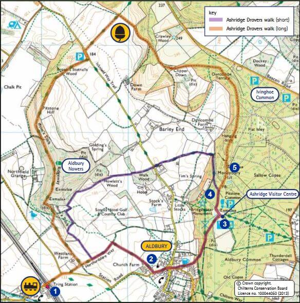
The Ashridge Drovers Walk has 4-mile or 6-mile circular route options through farmland, woodland and commonland and past the National Trust Ashridge Estate Visitor Centre.
START/END: Tring station
DISTANCE: Short route 4 miles (6.4km), Long route 6 miles (9.7km)
MAP: Ordnance Survey Explorer 181 Chiltern Hills North
You can download Chilterns Area of Outstanding Natural Beauty’s map of the walk here.
Explore deep into the beech woods of the National Trust Ashridge Estate and out onto the chalk downs with great views. The Ashridge Drovers Walk follows typically Chiltern sunken lanes once used for droving livestock from villages to graze on commonland. Much of the walk is through commonland which was once open but nowadays is a mixture of grassland, ancient trees and relatively young woodland. Aldbury, Pitstone and Ivinghoe Commons are all within the Ashridge Estate and are three of the 200 commons in the Chilterns. There is a 4-mile circular route option or a longer 6-mile route.
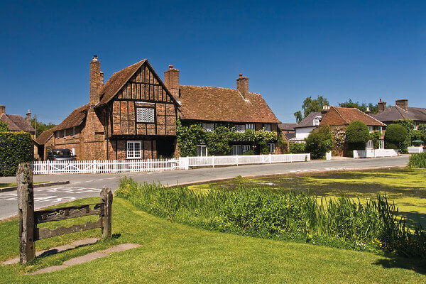
The Ashridge woods have some great bluebell displays in late April and early May. Also take in Aldbury, one of the prettiest villages in England with its village pond and stocks. You can start, break or finish your walk with a tasty meal or refreshing drink. On weekend afternoons in summer you can also climb the Bridgewater Monument at the Ashridge Visitor Centre for the best views in the Chilterns.
The Walk
From Tring Station [1] turn right. Follow Station Road, after the junction take a track left over a cattle grid and continue straight on at a junction of bridleways. Turn right onto a footpath leading into Aldbury.
Follow the path, past farm buildings on your right and a pond on your left, continuing straight on to the road. Turn
left towards Aldbury [2], past the church and straight across the crossroads, with the village pond on your left on to Toms Hill Road. After 30 metres take the bridleway on the left signposted ‘Bridgewater Monument 1/2‘, it is quite a steep climb.
At the top, skirt around the green until the Bridgewater Monument is on your left, take the Ashridge Boundary Trail on the right [3].
[4] For the shorter walk , turn left onto a footpath and descend out of the woods into farmland. After crossing Stocks Road, follow a bridlepath through Walk Wood onto Stocks Golf Course. The path goes around the outside edge of the golf course and meets up with the bridleway you first took from Tring Station.
[5] For the longer walk , continue to follow waymarks for the Ashridge Boundary Trail. After 1.5 miles, the waymarked path forks left from the stony track, following the woodland edge and across open downland to meet the Ridgeway. Turn left on to the Ridgeway.
Follow the Ridgeway National Trail’s distinctive black fingerposts, bearing an acorn, over Pitstone Hill and through
Aldbury Nowers back to Station Road. The Ridgeway National Trail follows much of what is thought to be Britain’s oldest road. Starting in Wiltshire, it travels for 137 km passing through the Chilterns to finish at Ivinghoe Beacon.
You can download Chilterns Area of Outstanding Natural Beauty’s map of the walk here.
Our thanks to Chilterns Area of Outstanding Natural Beauty.
NEW APP!! The Ashridge Drovers Walk is available as part of a free walks app for Apple and Android devices. Simply download the Handheld Tours App and select the Chilterns AONB folder which lists all the Chilterns walks. All details here: www.chilternsaonb.org/explore-enjoy/interactive-map.html#212