
Berkamsted Common
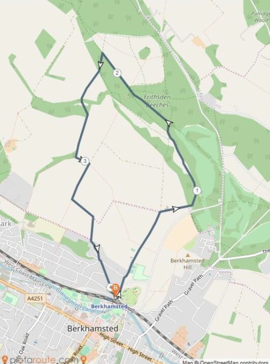
This 4.1 mile circular walk starts and ends at the rail station in Berkhamsted in the west of the county.
DISTANCE: 4.1 miles/6.6km
START/FINISH: Berkhamsted Railway Station
ACCESS: No stiles but there are hills and muddy sections
You can download CPRE’s full details and map of the walk here.
Nearly all of the walk is within the Chilterns Area of Outstanding Natural Beauty, and the first half of the route follows part of the Hertfordshire Way, the 195-mile long-distance path around the whole of Hertfordshire. The walk includes ancient beech woods, open common land with long views, undulating agricultural land and several sites of historical interest. There are no stiles, but there are hills and muddy sections.
Notable places of interest along this walk include:
- Berkhamsted Castle. This is the site of an 11th-century motte-and-bailey castle where, in 1066 after the Battle of Hastings, William of Normandy received the crown of England. Administered by English Heritage, the castle is free and open to the public 365 days a year.
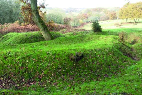
- Kitchener’s Field and the World War I practice trenches. During the First World War, the Inns of Court Officers Training Corps, nicknamed ‘The Devil’s Own’, were billeted on Kitchener’s Field and as part of their training dug extensive practices trenches on Berkhamsted Common prior to being deployed to the western front.
- Berkhamsted Common. In 1866 an attempt was made by the then owner, Earl Brownlow, to enclose part of the Common. The railings he put up were removed in a single night by 120 navvies and after a long court battle the commoners’ rights were upheld.
- Alpine Meadow Nature Reserve. Administered by the Herts & Middlesex Wildlife Trust, this Site of Special Scientific Interest is a chalk grassland rich in wildflowers, birds, butterflies and lizards.
There are many public footpaths on Berkhamsted Common, some leading into the National Trust’s 5000+ acre Ashridge Estate. The CPRE Herts route can serve as the starting point for a much longer walk through Ashridge if desired.
The Walk
The walk starts and finishes at Berkhamsted rail station. (Point B on the map). Nearest postcode is HP4 2AJ.
From the north side of the rail station (away from the town centre), walk north along Brownlow Road. There are houses on the left and Berkhamsted Castle on the right. After one-tenth of a mile where Brownlow Road curves to the right, you keep going straight ahead onto Castle Hill.
After about 80 yards, cross the street and follow the footpath as it enters the Berkhamsted School car park and Kitchener’s Field.
For the next two miles you will be on The Hertfordshire Way ‘clockwise direction’, waymarked with white roundels.
Walk straight on through the car park and past the tennis courts.
The public footpath continues straight ahead in a northerly direction as you leave the car park. You will soon be on a grassy path heading along the valley towards a farm. Keep the hedge on your left.
You will soon pass through a metal kissing gate into a horse pasture.
Leave the horse pasture through another kissing gate and turn right. Walk up the farm lane keeping the farm buildings on your left.
Where the farm lane turns right, you keep straight ahead on the footpath as it enters the wood. Although seemingly unmarked, there is a signpost just inside the wood on the right. Keep following the white ‘clockwise direction’ Hertfordshire Way waymarks.
Walk about 30 yards to a path junction with a tall metal signpost marked ‘WW I Trenches’. Turn left here and proceed up the hill through a wood.
At the top of the hill, turn left onto the broad level bridleway and proceed along Berkhamsted Common for about 120 yards to the first of the World War I practice trenches on the left. It’s worth taking some time at this very evocative place. You can walk along the trenches, read the informative signboard and have a rest on the memorial bench.
When you are ready to continue, keep following the white ‘clockwise direction’ Hertfordshire Way waymarks in a northwesterly direction along the upper path, with a wood on your right and open land on your left. There are good views to the south.
About one third of a mile beyond the trenches, turn right at the path junction with a signpost.
After only 90 yards, turn left at the next path junction and signpost. Walk ahead in a northwesterly direction – this is more of Berkhamsted Common. An ancient beech wood (Frithsden Beeches) is on your right.
Continue in a northwesterly direction across a gravel drive, and straight ahead on the footpath, still following all of the white ‘clockwise direction’ Hertfordshire Way waymarks.
At the next path junction there is a wooden signpost marked ‘Alpine Meadow’. Turn left here. You are now leaving the Hertfordshire Way. Walk in a southerly direction on the path through the wood.
After one tenth of a mile, veer right to a metal kissing gate. Proceed through the gate and follow the path along a field edge, with horse pastures on the left and a hedge on the right.
Continue straight ahead with the hedgerow on the right through three more gates and into the Herts & Middlesex Wildlife Trust Alpine Meadow Nature Reserve. Follow the path as it goes down the hill through the meadow and a wood.
Continue along the path as it starts uphill again. You will emerge through a metal kissing gate and the path then heads uphill between two fences, with a view of undulating fields on your left.
At the top of the hill, pass through another gate and keep straight on with a field on your left and hedge on your right. At the end of this field, turn left (due east) and walk along the field edge to a path junction with a wooden bench and well-festooned, ivy-covered signpost. Turn right here.
Now walk along the path at the edge of this next field, keeping the field on your right, and pass through a metal kissing gate at the far end of the field.
Once through the gate turn left, and follow the grassy path immediately adjacent to the trees and hedgerow on your left (the high path, not the lower path in the valley).
Follow this path as it gently descends and then starts to curve to the right and back uphill. Keep following the path through another metal kissing gate, then walk up the hill between two fences, emerging onto a lane with barns and houses.
Turn left and walk along this lane. It soon meets the main road, Castle Hill. On your right is a small checkerboard wall dating from the 16th century when the stately home Berkhamsted Place was built here (demolished in the mid 20th century).
Now take the public footpath (The Lime Walk) from the top of Castle Hill down the hill. The path emerges onto Castle Hill Avenue. Keep walking in the same direction. You will soon reach Bridgewater Road where you turn left, and then cross the street to reach the rail station where you began the walk.
This route was last walked by CPRE in November 2019. You can download CPRE’s full details and map of the walk here.
With thanks to CPRE for supplying this walk. If you have enjoyed thw walk, please consider supporting CPRE Hertfordshire in their efforts to protect and celebrate the Hertfordshire countryside for everyone to enjoy. For more information on their work and how you can help, please visit the website at www.cpreherts.org.uk.