Berkhamsted Circular Walk
This is the fifth in our series of dog-friendly local walks.
Thank you to George Edwards for producing for us another fine walk around the area in which we live and work.
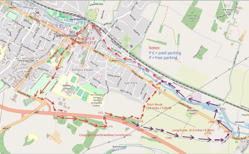
This one starts in the centre of Berkhamsted. The walk climbs steeply towards Kingshill Way, crosses underneath the A41, before crossing back over at Swingate Lane. It then follows a track which descends to the A4251 and returns along the Grand Union Canal towpath. The route is mainly on footpaths and enjoys several excellent views over the countryside. There is the option of extending the walk from 3.6 miles (5.8km) to 5.5 miles (8.9km) to Bourne End. There are several seats and numerous refreshments stops in Berkhamsted.
You can download a full description and annotated map of the walk here.
START: At Berkhamsted High St entrance to Water Lane car park HP4 3AP. Grid reference SP 99234 07821. Marked (1) on the map.
ENDS: At Berkhamsted High St entrance to Water Lane car park. Marked (21) on the map.
DISTANCE: Approximately 3.6 miles (5.8km), strenuous first section, but there are several seats near the top of the ascent. No fields with cattle, but part of the route goes through school playing fields and there are short sections of narrow lanes without a footpath, plus short sections of pavement before crossing busy roads. The last section is along the canal tow-path. Approximate height ascended 536 feet (163 metres). For the more energetic, the walk can be extended by about 2 miles (3km) to Bourne End before returning along the canal tow-path, which involves two sections of narrow lane without pavements.
MAP: Ordnance Survey Explorer 181 Chiltern Hills North
The Walk
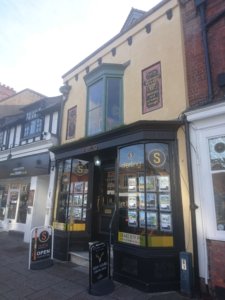 Berkhamsted High Street is the start of the walk and has been an important thoroughfare since before the time of the Romans, and was known by its Saxon name of Akeman St. Later it was known as Sparrows Herne Turnpike Trust and was an important toll road. Along the High St (173), towards Kings Road, is the oldest known “Jettied” timber-framed building in the country, built in the late thirteenth century, which survives as Sterling’s estate agent today (see photo). Crossing the High St carefully, go down Prince Edward St, which is between Oakleys Estate Agents and Mokana women’s fashion shop. Prince Edward Street is part of the road that originally led from the Castle to the town archery practice ground Butts Meadow, formerly known as the Buttericks or the Buttfield. Berkhamsted was the favourite home of the 14th-century Prince Edward, the Black Prince and coincided with the peak of the development of the Longbow as a weapon of war. At the end of Prince Edward Street, keep right of the Victoria Church of England Infants school (2), between the school’s blue fence and a wooden fence, then left alongside the school blue fence towards Butts Meadow playing field.
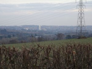
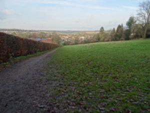 Take the path uphill across the playing field (3), just to the right of the hedge in front of the allotments and towards houses on the right, which back onto another open grassed area, known as Tompkins Meadow (4). Tompkins was a 19th-century Berkhamsted butcher who grazed his horses in this meadow. Follow the path steeply uphill between posts and grass on the left and wooden fences and hedges on the right. At the top of this grassed open area there is a seat offering excellent views back over Berkhamsted and Ashridge (5). After the seat, the path goes up a few steps between houses, emerging onto Berkhamsted School playing fields (6), with a clearly marked path between trees to Kingshill Way. There are further seats along this path.
Go through the gate (7) turning left on the Kingshill Way pavement towards the A41 roundabout and follow the pavement into Chesham Road to the traffic island opposite Ashlyn’s Hall drive. Carefully cross the road towards Ashlyn’s Hall drive (8) and walk down it until you reach the footpath signed (with warnings about low height!) to the right and under the A41 (9). Immediately after the A41 underpass turn left (10) along the public byway, parallel with the A41, through trees until reaching the tarmacked Swing Gate Lane (11). Taking care, turn left uphill and over the A41 bridge, then immediately right down the footpath signed, Public Highway Bourne End (12). This path roughly follows the A41 through trees and shortly there is a left fork which you should follow for the shorter route (13). The energetic can carry straight on to Bourne End before heading back along the Grand Union Canal – see further instructions at the end of the walk and the map.
 The shorter route emerges from the trees and then bears left downhill (14), with fine views to the right towards Bourne End and Hemel Hempstead. Follow the path down past houses on the left to Garden Field Lane, exercise caution as vehicles use the lane and there is no pavement. After a short distance the lane reaches the A4251 (15), where there are two laybys to the right which could be used as an alternative starting point. Turn left on the A4251, using the traffic island to cross this busy road, then turn right into Bullbeggars Lane (16). There is an additional small parking area here at the junction with Bank Mill Lane. Keep right at Bank Mill Lane uphill and then shortly afterwards left, entering the canal towpath at the road bridge (17) to return to the start. At Bank Mill bridge (18) the towpath changes sides of the canal, so you need to go onto the bridge and cross to the other side.
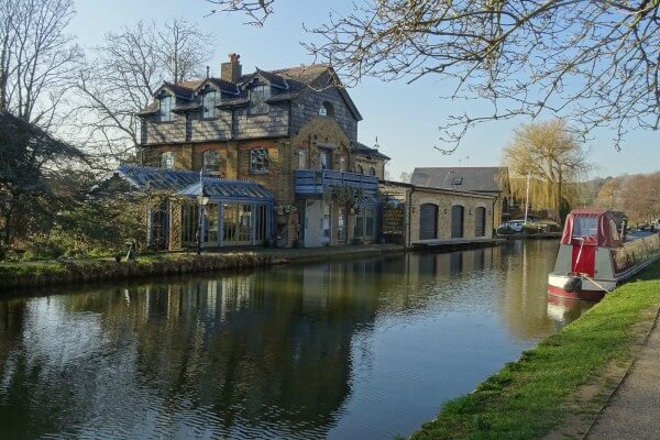
The canal towpath has some attractive properties alongside, old and new as well as several historical plaques describing the area as it was in previous times. One of these plaques describes the various wharves which were involved in former industries such as straw plaiting. Further on, just beyond Ravens Lane bridge, is a plaque describing the Port of Berkhamsted and some of the old buildings associated with the port are visible.
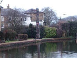 As the tow-path reaches the Castle St bridge, the famous Berkhamsted raven totem pole is visible (19). This stands on the site of a former timber importer who commissioned it in 1968 from a native tribe in British Columbia. The carving is a fertility symbol and legend has it that a woman wishing to conceive should visit and make three wishes for the child they dream of!
Just after passing under Castle St bridge, follow the towpath onto Station Rd, turn right and right again across Castle Bridge (20), right once more into Mill St. Here is The Moor, referred to earlier as the site of a temporary car park and with another plaque describing its history and that of the nearby Norman Castle. Follow Mill St past Berkhamsted School buildings on each side of the road into the Water Lane car park and the starting point on the High St (21).
Long Route
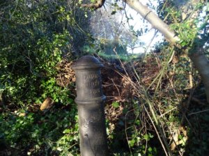 At point (13) on the map, carry straight on through the woods (purple arrows), with the path remaining close to the A41. Just before the path emerges from the woods, there is another path to the left back towards the shorter route. A little further on the left is an iron post commemorating the Foundling Hospital (13A), formerly at Ashlyn’s Hall.
In 1935 the Foundling Hospital moved from London to an impressive new building on the Ashlyns Hall Estate in Berkhamsted, where it continued until 1955 and eventually became Ashlyns School. The path remains close to the A41 and passes under several sets of overhead electricity cables, then goes left downhill and away from the A41. Ignore the metal gate and path to the right, which goes under the A41 and continue downhill towards Bourne End, passing a seat on the left (14A) and Gas pipeline markers on each side of the track. Ignore the farm track to the left and carry on towards a field on the left with trees around its edges and views of the A41 Bourne End Services on the right. Eventually the path reaches Sugar Lane, a narrow road with no pavement and several houses, so watch out for traffic. Descend to the A4251 (15A) and carefully cross over, turning left on the pavement back towards Berkhamsted. Just past St John The Evangelist Church is a right turn, Little Heath Lane (16A) – at this point there are bus stops to Berkhamsted and Hemel for those who may be feeling the strain. Turn into Little Heath Lane, exercising caution as this is a single-track road with no pavement, follow it for about 200 metres towards the canal bridge. Join the footpath on the left (17A) before the bridge onto the tow-path, turning left towards Berkhamsted. This section of the canal is more rural than nearer Berkhamsted, with the river Bulbourne and several ponds to the left. However, there is a sewage farm a bit further on, next to the canal lock, so it could be a bit smelly in hot weather! Follow the tow-path to Bulbeggars Lane (17) to re-join the shorter route once again.
Useful sources of historical information consulted in compiling this walk included:
Dacorum Borough Council – www.dacorum.gov.uk/home/leisure-culture/shopping-and-town-centres/berkhamsted
Berkhamsted Town Council – www.berkhamstedtowncouncil.gov.uk/town-guide.html
Berkhamsted Bowmen – www.berkhamsted-bowmen.org.uk
Dacorum Heritage Trust – www.dacorumheritage.org.uk/article/bringing-back-memories-of-the-hospital
Walk Directions © George Edwards 2018-19
You can download a full description and annotated map of the walk here.