
The Ridgeway and Aldbury Walk
Here’s the second in our new series of dog-friendly local walks
START: Layby, Northfield Road, Tring or Tring Station or Aldbury Village
ENDS: Layby, Northfield Road, Tring or Tring Station or Aldbury Village
DISTANCE: 4.2 miles (7km)
ASCENT: Around 152m (500 feet)
MAP: Ordnance Survey Explorer 181
This is a circular walk along part of The Ridgeway and through the picturesque village of Aldbury, which has two pubs and a village shop for refreshments. There are no stiles, or livestock usually, but Northfield Road and Aldbury Village can be busy during commuting hours or at weekends, so dogs should be on leads in these areas. Paths are generally well-marked but may be muddy. The walk includes an ancient track, a golf course and village stocks. Using public transport is possible; by train to Tring station or the 387 bus from Tring to Tring Station and Aldbury – see www.intalink.org.uk.
The Walk
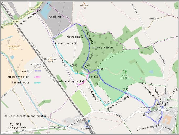
On Northfield Road, travelling towards Tring Station, there is a formal layby (1) between the roundabout on the B488, Upper Icknield Way and the track for Honeysuckle Farm and which is usually quiet and accommodates about five cars. In the unlikely event it is full there is another informal, unsurfaced area (1a) for about three cars closer to Tring Station. You may also be able to find some parking in Aldbury around the pond (8) or near the Valiant Trooper pub (7). The pub has a car park but ask permission before you use it.
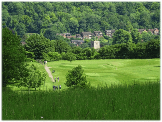
Starting from the formal layby (1) on Northfield Road, head back towards Upper Icknield Way and when you reach the wooded area turn right (2) through the gate and right up the hill between trees towards The Ridgeway path along Aldbury Nowers ridge. To your left you’ll glimpse a chalk pit, all that remains of Pitstone’s former cement works. Ignore a path to the right and carry on uphill through a metal gate, along the path to The Ridgeway and turn right through a wooden gate into a wooded hill path, which is Aldbury Nowers. Follow The Ridgeway path along the hill and admire the views over Tring and Aylesbury Vale to your right. A little way along the path is a seat and information board overlooking the view (3). Continue along the Ridgeway until you come to a steep stepped descent at the bottom of which is a signpost with four fingers (4) – take care down the steps! Take the left path towards Stocks golf club and shortly afterwards keep to the left path, going through a gate onto a path around the edge of the golf course with fine views towards Aldbury (5). Turn right following the edge of the course and wood until you come to another wooden sign and go straight on towards Aldbury village across the marked path over the golf course – watch for stray golf balls!
At the end of the golf course cross the Hertfordshire Way path towards Aldbury church. When you reach Church Farm there may be livestock in the field so dogs on leads. The path reaches Station Road which can be busy, so take care as you turn right along the grass verge for a few metres before crossing over the road to a metal gate with a footpath sign (6) into a field which may have cereal growing in it. Follow the path until it exits between houses into a cul-de-sac, Stoneycroft, with the Valiant Trooper pub (7) just to the left. Dogs are allowed in the bar and garden areas – see www.valianttrooper.co.uk. The alternative pub is the Greyhound Inn – http://greyhoundaldbury.co.uk/ – carry on along Trooper Road past the garage towards the village pond and stocks (8) – take care the road is narrow and has little pavement. On your left as you reach the pond is Aldbury Village Store an alternative source of refreshment to the pubs and with two convenient seats on the village green where you can study the village stocks.
Continuing the walk, make for the Greyhound Inn (9) and take the track to the left of the pub “Percy Crow Path” (10) which takes you into a field with the school on your left. Exit the field and immediately turn left towards Church Farm, turning right onto the path you came on towards the Hertfordshire Way. Reaching the Hertfordshire Way on the edge of the golf course, turn left (11) and follow it until it meets The Ridgeway and turn right (12) onto the Ridgeway. Follow The Ridgeway and where it begins its ascent and you’ll find a shady seat under a tree (13). Immediately after the seat take the left path downhill, back towards Northfield Road. Caution as you cross a private road to Northfield Grange (14) and carry on to Northfield Road where you turn right and back to the formal layby starting point.
You can download the walk in PDF format here.
History
The Ridgeway follows an 87 mile route used since prehistoric times by travellers, herdsmen and soldiers from Wiltshire to Ivinghoe Beacon. Grim’s Ditch follows The Ridgeway across Aldbury Nowers and is a series of linear earthworks thought to be a set of local boundaries used to control the movement of cattle and carts and dating back to the Iron Age. Aldbury is an archetypal historic village including a village pond, stocks and whipping-post, in excellent condition. The village was recorded as Aldeberie in the 1086 Domesday Book. The Valiant Trooper pub first traceable evidence dates back to 1752. In the 1970s, Aldbury was better known as the home of the head of the Playboy Club, Victor Lownes, who lived at Stocks House and held lavish parties there. The house and swimming pool featured on the cover of the 1997 Oasis album, Be Here Now. Aldbury is a popular location for films and television. Among film and television series scenes filmed in the village were: The Dirty Dozen, Bridget Jones: The Edge of Reason, Morse and inevitably Midsomer Murders.