Drayton Beauchamp
This is one of the walks recommended by Tring Town Council, and takes in Drayton Beauchamp and the surrounding countryside.
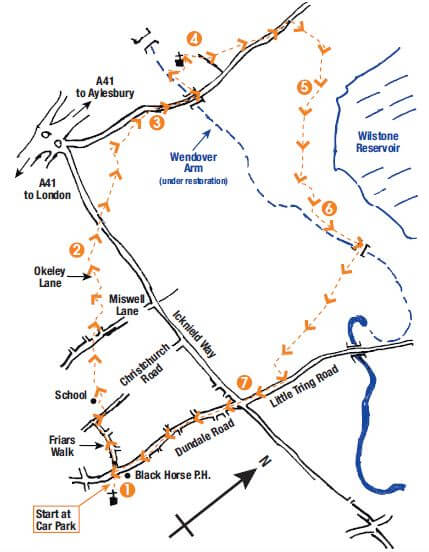
START/END: At the car park behind Dolphin Square. Marked (1) on the map.
DISTANCE: Approximately 4.5 miles (7.5km)
MAP: Ordnance Survey Explorer 181 Chiltern Hills North
You can download Tring Town Council’s full description and annotated map of the walk here.
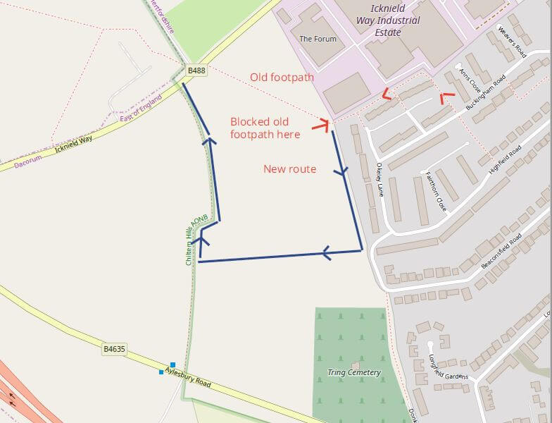
As a result of the Cala Homes Development, in Point 1 of the map after reference to ANNS CLOSE, walkers will need to follow a diversion. Cala has erected a fence around their site with room for a footpath south parallel to the gardens on Okeley Lane towards Highfield Road and walkers need to follow that to another new path just before Beaconsfield Road which turns right across the development and meets another new path which turns right again, north to Icknield Way. Once the walker meets Icknield Way they can follow the standard route once again. Please refer to annotated image.
Head for the entrance to the car park (1), by the Black Horse pub, and cross FROGMORE STREET to FRIARS WALK. Follow this road, which bears left at a junction after about 200m, to meet CHRISTCHURCH ROAD. Turn right uphill, cross the road and take the footpath on the left (signed Drayton Beauchamp) – follow this path up by the side of the school, then bear slightly right and take the obvious path across the playing field to MISWELL LANE. Cross to a fenced path immediately opposite. Cross the next road to another fenced path, and follow this round to another suburban road. Turn left (signed FP48a) and cross the road. Pass ANNS CLOSE and in 25m take another fenced path on the right (not signposted). Follow this path around and behind houses until the path becomes OKELEY LANE. Follow the lane to a field gate ahead.
Go through the gate and bear right diagonally across the field to another gate (2) – lovely views of the Chiltern ridge to the left. Cross the busy ICKNIELD WAY to a footpath opposite. Cross the stile and follow the path through a small copse, then bear right around old agricultural sheds to an obvious gate. Take a moment to look out across the Vale of Aylesbury, with the town itself straight ahead. Through the gate, follow the path straight across the field to a stile. Bear slightly left across the next field to its lefthand corner. Cross the stile there and continue down the next field to farm buildings. Cross the next stile onto a farm track, and follow this concrete track down to the road (ignoring a turning off to the right).
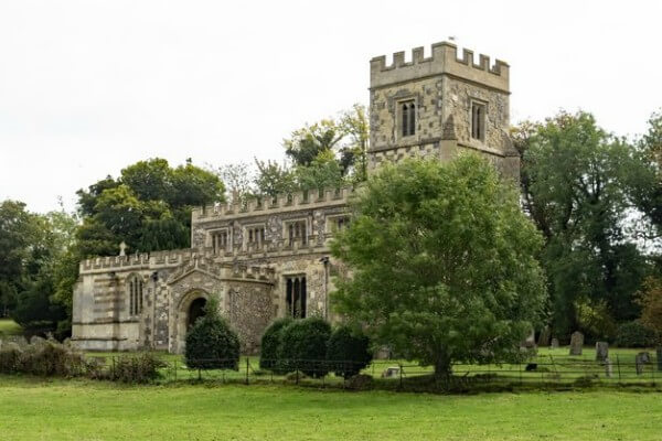
Turn right onto the road and follow it down to a bridge over the canal (3) – this is the Wendover Arm of the Grand Union Canal, currently under restoration. Cross the bridge and the adjacent stile, and descend to the towpath. Turn right, and with the canal on your left, continue along the towpath to a signed footpath on the right, which takes you up to the graveyard and the 15th century St Mary’s Church (worth a visit if it’s open). Observe the Old Rectory, as you take the track down to the right beyond the church.
At the next gated junction (4), bear right onto a track for about 50m, before taking the footpath on the left, diagonally across the field. Just past a pond on the left, go through the gate and turn left onto the road into Drayton Beauchamp village. Ignore the first footpath on the right, and continue along the road through the village. Just past the entrance to The Dower House, and just before Dray House, take the fenced footpath on the right. Bear right across the next stile (ignore those to the left at this junction) and follow the footpath to the right. Cross a little footbridge over a stream, to a gate. Then cross this field – the path can be a bit indistinct, but goes more or less straight, towards a telegraph pole in the bottom corner, and then through the gate behind it. (There’s a knot of tracks in this area, so be sure to head for the telegraph pole!).
Through the gate, cross another little footbridge and continue on the path to the left of the field, until you reach a hedgeline (5). Turn left here, and with a hedge continuing to your left, continue around the edge of the next field. Keep on the main path, which eventually turns sharp left, to follow the bottom of the next field, then around to the right and up hill to the canal (Wendover Arm) towpath.
Here turn left, and follow the towpath (6) to the next bridge (wooden footbridge no. 4). Currently (2018) restoration continues, to make the canal navigable again to Wendover. Take time to observe the renovated Whitehouses pumping station (built 1820), and enjoy the views over Wilstone reservoir to the left. Cross the canal at the bridge – go through the gate, and uphill to the next gate. With the outskirts of Tring now in sight, straight ahead, continue with the hedge to your left. Note the views across to Ivinghoe Beacon, the start of the Ridgeway National Trail, to your left. At the junction of paths, continue straight up over the next hill. At the far end of the field, take the obvious footpath to the left, and follow this to LITTLE TRING ROAD. Turn right here, and follow the road down to its junction with ICKNIELD WAY (there’s a pedestrian path adjacent to the roadway).
Cross this busy main road (7), and continue into DUNDALE ROAD opposite. Follow this all the way down into town. Towards the end, it becomes FROGMORE STREET. When you reach the Black Horse pub you’ve come full circle – turn left into the car park.
NOTE: Conventions: stiles are progressively being replaced by kissing gates, so beyond publication date (2018), you may find this has happened in places on this circuit.
You can download Tring Town Council’s full description and annotated map of the walk here.
With thanks to Tring Town Council. www.tring.gov.uk. Their Information Centre is open weekdays from 9.30am-3pm, Saturdays 10am-1pm. 01442 823347.