
Ivinghoe Beacon Walk
Here’s the third in our new series of dog-friendly local walks.
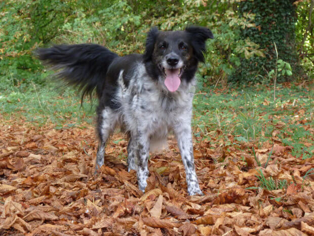
‘This walk is dedicated to Meg (pictured, 2004-2018), our loyal Collie rescue dog, who gave us so much pleasure on our walks over the years.’ – George Edwards.
START: National Trust car park (free) Ivinghoe Beacon (Beacon Road), OS grid reference SP963 159
ENDS: National Trust car park Ivinghoe Beacon
DISTANCE: 3 miles (5km)
ASCENT: 3 miles (5km) Height ascended/descended about 475feet (145 metres)
MAP: Ordnance Survey Explorer 181
This walk is a part circular along a less popular route from the free National Trust car park at Ivinghoe Beacon on Beacon Road, just off the B489 road from Tring to Dunstable, a Site of Special Scientific Interest (SSSI). The walk has spectacular long distance views over the Vale of Aylesbury and an opportunity to see one of the many herds of Ashridge wild deer, as well as various other wildlife, depending on the time of year. There are no stiles, few gates and little livestock usually (except occasionally sheep and deer), although sheep and cattle widely graze on other parts of the Ivinghoe Beacon hills. Paths are generally well-marked, apart from the first section, but may be muddy and slippery on chalk after rain. Refreshments can be obtained from the Bridgewater Arms in Little Gaddesden – www.greeneking-pubs.co.uk/pubs/hertfordshire/bridgewater-arms-hotel/ or the Rose and Crown in Ivinghoe – https://www.roseandcrownivinghoe.co.uk (but note very limited on street parking).
The Walk
Parking in the free National Trust car park (1) near Ivinghoe Beacon isn’t usually a problem except on summer weekends and Bank Holidays (or if filming is underway as it is a popular location, Star Wars was being filmed on a recent visit!). If full or closed for any reason, there is parking on grass further on Beacon Road towards Ringshall on both sides of the road, but it can be rough and muddy after rain.
With the car park and Dunstable behind you, walk downhill towards the car park entrance nearest Ivinghoe and at Beacon Road turn left by the National Trust signpost, walking uphill on the grass verge beside the road next to a small group of trees. At the end of these trees look across the road and you should see a short, steep and narrow chalk track up the bank heading between low trees. Carefully cross the road and up the track through the trees which quickly opens out into a meandering uneven track, which then veers right, joining a wider horse track, signed permit holders only, with a horseshoe. Follow this horse track and shortly take the left branch, coming out at a T junction (2) with another well-used stony path, turn left. Follow this path gradually downhill, noting a gate on the right offering fine views towards Aylesbury across Incombe Hole. Carry on downhill until you come to a five-barred gate (3) at the top of a steep track leading down towards Pitstone Hill in the distance. Turn left before this gate onto a woodland path on the edge of the hill. After a short distance it descends to cross another path, ignore this cross path which offers fine views to the right of Pitstone windmill and beyond. Carry on through the edge of the wood, until you reach a wide stony track which leads to Clipperdown Cottage and Ashridge monument eventually – watch out for occasional vehicles on this track.
Turn right onto this track (4) and almost immediately go through a gate to the left of a cattle grid. Follow this wide track and the field fence on the right until it descends and the right-hand fence makes a right turn downhill. Follow the narrow path (5) which goes downhill parallel with this fence. Follow this narrow path downhill through trees, ignoring a path crossing left to right and looking out for deer, which I’ve often seen in and around the trees. At the bottom the path goes between farm buildings at Down Farm and dogs should go on a lead. Follow the farm track through these buildings towards the Aldbury Road and just after the road to the farm house, turn left (6) onto the clearly marked permissive path alongside the field edge. Often deer can be seen on the hillside to your left. Follow the path until just before a large house at Barley End, where it turns left (7) into another field popular with deer. Turn right along the boundary with the house until the hedge at the end of the field, where the path goes steeply left uphill, then right through the hedge (8), by a bird box on a post and turn left to a gate. Go through the gate and left following the well-marked grass path rising gently uphill and curving right. Often you can see deer and red kites from this path. Eventually the path reaches trees and a redundant gate, go through into the next field where there may be sheep grazing. There was a fallen tree across the path, but it can be easily avoided and continue climbing the field to a metal gate in loving memory of Geraldine Spicer. Go through the gate uphill to the wide track leading to Clipperdown Cottage and Ashridge Monument and turn left (9), watching for vehicles once again. Follow this track, ignoring the left branch downhill until you reach the cattle grid and gate once again (10). Go through the gate and follow the track to Beacon Road (11), where there is additional car parking on the grass verges, carefully crossing the road to the left and making for a path parallel with the road under the trees. On your right you’ll see Edlesborough chalk lion in the distance (12). Follow the path back towards the National Trust car park (13).
You can download the walk in PDF format here.
![]()
History
Ivinghoe Beacon is one end of the ancient path The Ridgeway, which stretches 85 miles (137km) from Overton Hill near Avebury, Wiltshire. It has been used for 5,000 years by many different groups of people; travellers, farmers, and armies. It became a National Trail along with 14 others in England and Wales, in 1973. It is a public right of way.
Although Ivinghoe Beacon is not the highest point on the Ashridge Estate, it is definitely the best place to enjoy spectacular views of the surrounding countryside. As you walk across this windswept landscape look about you for signs of the past. There has been human activity on this site since the Bronze Age. Bronze Age burial mounds can be seen throughout the area – all are Scheduled Ancient Monuments. You can see many deeply rutted ‘cattle drovers’ paths and cross-ridge dykes throughout the Ivinghoe Hills. Our ancestors farmed this landscape for centuries and the cattle and sheep you see here today are a continuation of that process. The animals create the right conditions for wild flowers and butterflies to thrive. Towards Incombe Hole (between points 2 and 3 on the map) you can see the work of our ancestors at the prehistoric earthwork, Grim’s Ditch. In spring and summer and you will see lots of wildflowers and butterflies that thrive in the chalk grassland. There are rare orchids, the delicate pasque flower and even rarer butterflies such as the rapidly declining Duke of Burgundy. Ashridge wild deer are visible on this walk during most times of the year, but exercise special caution during the rutting season, in October-November.