
Little Tring

Discover the Wendover Arm of the Grand Union Canal and the historic Tringford pumping station on this circular walk, which starts from Tring Town Centre
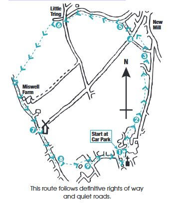
START/END: Frogmore Street East car park
DISTANCE: Approximately 3 miles (5km) allow 1hr 3om
MAP: Ordnance Survey Explorer 181 Chiltern Hills North
You can download Tring Town Council’s full description and annotated map of the walk here.
The Walk
From FROGMORE STREET EAST car park [1] (behind DOLPHIN SQUARE and the Church of St Peter & St Paul) head northwards towards the NORA GRACE HALL. Passing the hall on your left, keep on the main path across the POND CLOSE play area and walk beside a flint wall.
When the wall ends ignore all paths to the left (leading to houses) and continue on the main path [2] which runs below tall ash trees. Below lies the STREAMSIDE WALK environmental area, to which the path gradually descends.
Cross SILK MILL WAY to a footpath with tubular fencing to its right and continue on path to another road junction ahead.
Bear slightly right and cross NEW ROAD [3]. Take the path left, beside the ‘feeder stream’. Keep to the tarmac path until it reaches the UPPER ICKNIELD WAY, once an ancient track linking East Anglia with the Wiltshire Downs, but now a busy road. [4] Cross carefully. There’s a pedestrian crossing just to the right.
The path continues to follow the stream until it flows into the WENDOVER ARM of the GRAND UNION CANAL. [5] Turn left and continue along the canal to the old ‘stop lock.’
Just before the stop lock opposite is TRINGFORD PUMPING STATION, which pumps water from the TRING RESERVOIRS into the Wendover Arm whence it flows into the GRAND UNION CANAL at Bulbourne. Keep walking beside the canal, up to the road bridge. Climb the steps and cross the road at LITTLE TRING to the footpath opposite.
[6] Continue to follow the path with the canal still on your right to a junction and then bear left, whilst the canal curves away to your right to its current (2018) terminus. Follow this path to a gate and a four-way path junction.
At the gate, continue straight on, with a fence to your right. When the fence ends, take the gate on the right and continue to the next field gate.
Go through the next gate and turn left onto the well-defined track between hedges towards MISWELL FARM. This track joins the farm lane which climbs to the right up the hill towards Tring in a deep and steep cutting beneath Beech trees.
[7] Cross the busy UPPER ICKNIELD WAY again, into MISWELL LANE, noting on the left the old WINDMILL and on the right the rookery in the trees beside the road.
Continue down MISWELL LANE, crossing WINDMILL WAY to Goldfield playing fields on the left. [8] Take the path to the right towards the school with playing fields to the right. At the three-way path junction continue straight on to eventually meet CHRISTCHURCH ROAD. [9] Turn right and go down the hill to FRIARS WALK. Turn left into FRIARS WALK and continue, keeping right, to a T-junction with the Black Horse pub opposite. Cross the road and return to the car park.
You can download Tring Town Council’s full description and annotated map of the walk here.
With thanks to Tring Town Council. www.tring.gov.uk. Their Information Centre is open weekdays from 9.30am-3pm, Saturdays 10am-1pm. 01442 823347.