Pavis Wood Walk
Here’s the fourth in our series of dog-friendly local walks.
This one starts at the highest point in Hertfordshire (801ft or 244m) in Pavis Woods, Hastoe. It’s 3.2 miles or 5.1km long or, for the energetic, an additional 3.5 miles or 5.7 km from Tring.
START: At the entry to Pavis, Black and Northill Woods Nature Reserve, at the junction of Shire and Gadmore Lanes, Hastoe. Grid reference: SP 91419 09186. For the more energetic you can walk from the centre of Tring and we have provided directions from Tring High Street / Akeman Street to the start of the short route in Pavis Woods, avoiding most roads.
ENDS: Pavis, Black and Northill Woods Nature Reserve entry, at the junction of Shire and Gadmore Lanes, Hastoe. The more energetic can walk back to Tring, following a similar route to their outward journey, where there are a number of refreshment places in the town.
DISTANCE: Approximately 3.2 miles (5.1km). Mostly easy but can be muddy in parts. There are two stiles (both with ‘dog holes’ when checked), and one or two fields may have cattle. Approximate height ascended 220 ft (67m).
For the more energetic, walking from and returning to Tring High Street, adds about an extra 3.5 miles or 5.7km and an initial steep ascent of about 400ft (122m). There may be some sheep on this longer route.
MAP: Ordnance Survey Explorer 181 Chiltern Hills North
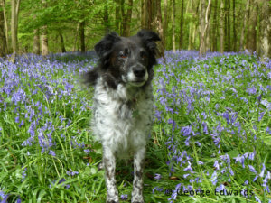
The shorter route is an easy circular from Pavis, Black and Northill Woods Nature Reserve in Hastoe, the highest point in Hertfordshire. It includes an area with a regular carpet of bluebells during April/May, along parts of the Ridgeway, Chiltern Way and Grim’s Ditch, mentioned in previous walks in this series.
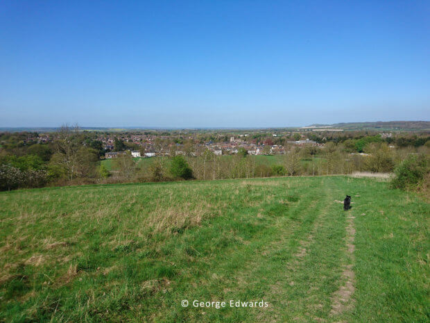
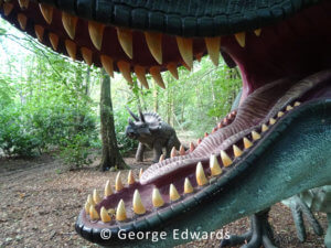
Those starting in Tring will see excellent views over Tring, Tring Park and Aylesbury Vale during their ascent to Pavis Woods. The walk goes through several woodland areas where there may be a danger of falling branches, or even falling trees in high winds, so please exercise care in adverse weather. There is also a rather unique opportunity to see some dinosaurs and perhaps a fairy garden! Refreshments can be found at various places in Tring.
The Walk
For those starting in Tring there are various public car parks, as well as on-road parking on Hastoe Lane between Park Road and the A41 bridge. There is a small amount of parking for about three cars at the entry (8) to Pavis, Black and Northill Woods Nature Reserve, which isn’t usually busy, or on Shire Lane, or in Hastoe. Please avoid blocking the narrow roads or driveways in Hastoe.
For those starting at Pavis Woods, skip this first section (1) to (7).
Tring High Street / Akeman Street Start
Walk down Akeman Street, signposted ‘Museum’, past various yards indicating their previous functions, such as Brown’s Maltings. At the end of Akeman Street, on the left, is the Natural History Museum (2).
Immediately after the museum turn right into Park Road, then immediately left into Hastoe Lane (signposted ‘Cholesbury’ and ‘Hastoe’), following it until just after the A41 bridge (3), where there is a wooden gate and concrete track leading steeply uphill, signposted ‘Stubbing’s Wood’. As you pass the field boundary gateway, a path goes left steeply uphill (4). Follow this towards the woods at the top of the hill (Stubbing’s Wood). Looking back there are excellent views over Tring all the way to the top of the hill. As the path crests the hill, it moves closer to the woods with a seat on the right and new wooden fencing to the left. After moving closer to the edge of the woods, you’ll see a path into the woods (5), follow this path and keep left uphill at the edge of the wood. Ignore a path going left and carry on slightly uphill into a bit of a clearing, ignoring a path crossing left to right going steeply downhill. The path then moves into denser trees. Again, ignore a path to the left, and take care round a hollow on the right where the path is narrower. After a short while the path descends out of the woods down steps. Go straight over the stony bridle path, signed ‘Pavis Woods’ & ‘Shire Lane’ (6). Go along the narrow footpath with a tall house (Hastoe Grove) boundary fence on your left, downhill to another path crossing left to right downhill. Cross straight over and through a metal gate into a small wood, signed ‘Public Footpath over private land’, on to a left path which goes uphill, then passes through a small wood, before emerging into a field with a well-marked path with excellent views over Aylesbury Vale. Take the right-hand path, with the seat on your left, parallel with a field hedge, towards Pavis Woods and exit the field through a metal gate (7) down on to another bridle path. Turn left uphill towards the main entrance of Pavis Woods (8).
Pavis Woods Start
 At the entry to the nature reserve go through the metal gate, signed ‘Ridgeway and Riders’ Route’, following the wide, well-marked path through the trees close to the fields. After 300m or so into the wood, during the bluebell season, there is always an extensive carpet of bluebells to the left (9) where you can see signs of another path through the trees and bluebells. However, carry on and after another 200m or so you reach a cross-road of paths (10). Take the left path, signed ‘Footpath’, leaving the Ridgeway. This path shortly leaves the wood and heads into an open field, which may have crops growing, but the footpath is usually well-defined and heads straight towards a hedge (11) and woods in the distance. The hedge has a stile with a gap alongside; go through, crossing Grim’s Ditch farm track, carefully watching for farm vehicles.
On the far side of the track, to the right of an electricity pole, is a footpath sign pointing along the field edge towards Buckland Wood. Off to the left, in a dip, are some ramshackle buildings surrounded by barbed wire, which may have had some military purpose originally. Follow the path on the edge of the field, entering the wood through a metal kissing gate (12). The path here is dark and may be muddy, winding through the trees. The path gradually descends – ignore paths to the left. Continue descending to a wooden footpath sign (13) indicating a right hand and straight-ahead path. Continue straight on ascending an ill-defined path towards the edge of the wood and a wooden gate into a field (14), which may contain cattle, so keep any dogs on leads. Head across the field just left of an electricity pole towards a gap in the hedge, to the right of which is a wooden gate into another field (15). Should cattle be present near these paths, you could avoid them using an alternative footpath to the left (15), which emerges in Drayton Wood at point (18) on the map. If continuing on the main route, go through the gate, following a defined path next to a hedge, then a wooden fence leading to another wooden gate on to a metalled farm track, which leads to Bucklandwood Farm. Turn left on to this track, watching for vehicles, and follow it until it reaches some houses on Little Twye Road (part of walk 1), then turn left (16). Follow the road down to Beechwood Farm where the road ends and continues as a bridle path up a slope alongside Drayton Wood. Shortly on the left there is a stile (and ‘dog hole’ alongside) with a signpost into the wood. Go over the stile (17), but be warned the path here can be quite muddy after rain. An alternative route is to carry on the bridle path until it meets Shire Lane (17a) and turn left, re-joining the main route at point (20).
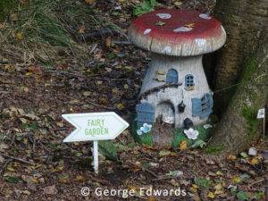 In the wood the path bends right, then left and shortly opens into the unexpected sight of three large dinosaurs someone has taken a lot of trouble to put there, but for no obvious reason! Very often there has also been a number of small fairy figures in a fairy garden scattered about this part of the wood, so look out for them.
 After the dinosaurs you will come to another stile and, again, someone has made a ‘dog hole’ in the wire alongside. Ignore the marked path to the left (18) and follow the path as it bends right, eventually reaching the edge of the wood and a metal gate (19) leading to a path between two paddocks. This path leads to Shire Lane and another metal gate (20). Carefully cross Shire Lane on to the marked path opposite in a small wood, which bends left then right and comes out into a field with a marked path crossing left, going behind a field hedge towards some trees. Follow the path towards the trees and turn right along the marked path at the field edge (21). There is an uneven parallel track through the trees, which is a continuation of Grim’s Ditch.
At the end of the trees and path go through a wide field entrance into Browns Lane (22), a green lane. Turn left uphill towards the houses and Hastoe. Passing between houses you start to descend gently to a road junction (23); turn left into Gadmore Lane, back towards Pavis Woods and the start (8). For those returning to Tring rather than Pavis Woods, just after turning into Gadmore Lane, there is a wide track on the right to Hastoe House and Hastoe Grove; follow this towards Grove Wood. At the right of Grove House, go down the bridle path to the end of the tall fence on your left, where you will see steps on the right up into Grove Wood (6). Follow the same path back to Tring that you took on the outward journey.
Walk Directions © George Edwards 2018-19
You can download the walk in PDF format here.