
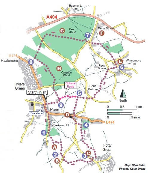
Penn Jubilee Wood Walk
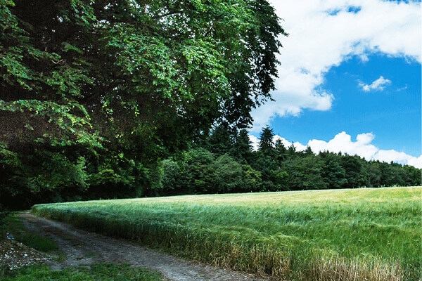
A more strenuous walk that visits Jubilee Wood, planted in 2012 to mark the Queen’s diamond jubilee, and several historic villages. There are a couple of shorter options.
START: The Red Lion, Elm Rd, Penn HP10 8LF. Grid ref:SU 907937. Park alongside Widmer Pond, opposite The Red Lion
DISTANCE: 10 miles/16km, with shorter 5 and 6 mile options
TERRAIN: Easy walking on good paths, with numerous gates and stiles. The main route has two uphill sections with a total ascent of 820ft/250m. Both shorter routes have one uphill section of c490ft/150m
MAPS: OS Explorer 172, Chiltern Society 6 & 13
REFRESHMENTS: The walk passes by or close to The Red Lion and The Crown Inn in Penn, The Royal Standard of England in Forty Green, The Plough and The Potters Arms in Winchmore Hill and The Hit or Miss in Penn Street
LOCAL TRANSPORT: There are bus stops at the start of the walk by Widmer Pond. Please check www.traveline.info for services.
You can download The Chiltern Society’s map of the walk here.
The Walk
With The Red Lion behind you, turn left along the narrow lane and continue beside the main road to Slades Garage. Cross to the left of the garage, walk along Beacon Hill for 660m and take the path on the left opposite ‘Claremont’.
- Go over the stile, through the wood and over the next stile into the Chiltern Society’s Penn Jubilee Wood. Head straight across the field, through a gate and continue for 250m to a path on the left. Turn left along the left-hand field edge and, just before entering the wood, turn right along a permissive path. At the end, turn left into the wood to a T-junction, turn right for a few metres, then fork right on The Chiltern Way (TCW), to a stile at the corner of the wood. Cross it and turn left over a second stile into a field.
- The route follows TCW’s Berkshire Loop for almost a mile. Cross the field and a stile onto a lane. Turn right along it for 60m and take the path on the left opposite the farm buildings. Cross the first stile, continue ahead over the second, and turn right along a wide track. In the next field, turn immediately left downhill and climb up the other side to cross the stile at the top. Follow the path through woodland, bear right down the left-hand field edge and up over a stile on the left into the next field. Stay in the same direction up and over two further stiles, then go through a gate onto a lane. Turn left up to the The Royal Standard of England.
- Turn right towards the pub car park and immediately right along a narrow lane to a gravel driveway at the end. Turn left through a gate, fork left and follow the path through three further gates into a wood. After a few metres fork left, following the path along the edge of the wood for 550m and through a gate onto an unmade lane. Walk up the lane to a path on the left just after a pair of metal field gates.
- Turn left along the path to a lane, Pauls Hill. Turn right and go past the church to the main road. Cross it, turn right along the pavement and take the path straight ahead at the entrance to The Crown Inn car park. Turn left along the field edge and left again along the bottom of the car park into the woods. Follow the path round to the right, continue downhill then straight across the field to a major path junction. *The optional shorter route starts here.
- Turn right along the wide track on TCW to Winchmore Hill. At the lane, turn left and immediately right through a gate into a field. Turn left along the field edge and through a gate on the left onto a busy lane. Cross it, go past the gate opposite and bear right uphill along the field edge and into the next wood. Fork left to a surfaced driveway and turn left up it. Just before the left-hand bend, bear right off the driveway and straight ahead over a crossing path. At the end, turn right through a gate and cross the lane past a pond, Gawde Water. Continue ahead through two gates onto the grass of Winchmore Hill Common.
- Turn left past the children’s play area, cross the road and walk down to the bus shelter. Cross to the path opposite and stay in the same direction through two gates into a wood. Continue along the left-hand edge and through a gate into a field. Fork left across the field and pass through two more gates to a road in Penn Street. Cross the road and bear right past the village hall along a lane signposted to Penn and Beaconsfield. At the corner, continue straight ahead past the barrier into Penn Wood.
- Walk directly ahead for 100m, then turn left along a wide track for a further 100m and follow it round to the right. Stay on this wide track for 1.6km, passing The Penna on the way, then go down through a gate onto a busy road. Cross it into Common Wood and follow the main path ahead as it first descends then climbs to a noticeboard near the edge of the wood.
- Facing the map on the noticeboard, bear right for a few metres and turn right onto a wide path along the edge of the wood. Where the field on the right ends, cross straight over onto a smaller path and follow it for 180m to a junction. Fork left. Where the signed ‘long trail’ turns left, continue straight ahead and down to a lane. Bear right across it, take the path uphill and round to the left to leave the wood into a field. Cross straight over it and go through a gap in the hedgerow to where the shorter optional walk rejoins from the left.
- Continue ahead, follow the track round to the right past the farm buildings and continue along to return to The Red Lion.
*Optional shorter route – Turn left along the wide track for 200m and bear right to the top. Turn left along the hedgerow and leftagain at the end to rejoin the main route at waypoint 9. There’s also the opportunity to make it a figure-of-eight walk by reversing the shorter route back to waypoint 6 and then following the main route.
You can download The Chiltern Society’s map of the walk here.
With thanks to the Chiltern Society for supplying this walk and images.