Walks Around Town

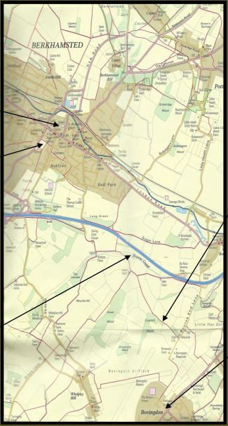
This walk is called ‘The Devil’s Own Footsteps’ and is a 4.3 mile linear walk starting at Berkhamsted Railway Station and ending at Bovingdon Memorial Hall.
START: Berkhamsted Railway Station.
END: Bovingdon Memorial Hall
DISTANCE: Approximately 4.3 miles (7km)
MAPS: OS Explorer 181, Chiltern Society Footpath Map No19, Berkhamsted Citizens Association Footpath Map
You can download Berkhamsted Town Council’s full description of the walk here.
To download the audioguide please refer to the website.
You can park in Berkhamsted station Car park or there is public parking nearby at public car parks off Lower Kings Road.
On leaving the railway station cross Station Road, turn left and take the first right, crossing the canal by the pedestrian bridge and bear right along Mill Street. The Moor, an open grassed area, is on your right hand side.
Continue along Mill Street until you reach the High Street. Cross the road to Prince Edward Street and, at the end of the road take the footpath to the right of Victoria School. This path leads to an open piece of ground called Butts Meadow.
Follow the path along the left hand side of Butts Meadow as it climbs the hill and emerges into another piece of open grassland, known as Tompkins Meadow, where, behind you, a panoramic view opens up of the town in its valley setting. You can enjoy it from a helpfully placed bench.
At the meadow’s end follow a fenced-in footpath, until you emerge through a gate into playing fields. The footpath now roughly follows the line of trees (perhaps an ancient field boundary line) straight across the playing fields.
You leave the sports ground through a gate on to Kingshill Way. A signpost reads Town Centre 3⁄4. Turn left and walk along Kingshill Way to its junction with Chesham Road.
Cross Chesham road by way of the traffic island and follow a tarmac road. Where the road forks, bear right and look out for the entrance to a pedestrian tunnel under the bypass (A41) on your right. Go through the tunnel and turn left.
To your right, across the valley, is Haresfoot Farm, and just out of sight beyond, Haresfoot House, former home of General Smith-Dorrien, now a school.
You are now on a bridleway, and it takes you through a narrow strip of woodland known as Sandpit Green.
At the end of the bridleway turn right on to Swing Gate Lane and continue as the metalled road turns into the access lane to Bottom Farm and nearby cottages.
Continue along the same path which eventually joins a short stretch of metalled road close to Lower Farm, which you will see up the hill on your right. Where the farm access road bears left go right, through the gate to a signed footpath which climbs steadily through fields towards a gap in the treeline ahead of you.
After passing through the narrow strip of trees turn left and the path follows the edge of the field, with hedgerow to your left.
At the end of the field path turn right along a metalled access road, passing on your left the transmitting aerials of Bovingdon radio navigation beacon for aircraft. The airspace above the airfield and nearby Chesham is known as the Bovingdon stack. When Heathrow becomes congested, aircraft are requested to fly a holding pattern until a landing slot becomes available. So, if you spot aircraft circling overhead on a clear day, that’s the explanation.
The access road leads directly back to the now familiar clay path skirting the airfield, with the facilities of HMP The Mount now directly facing you.
The last section of the path, now enclosed and running alongside the prison perimeter fence, takes you to a housing estate. Turn left along Newhouse Road to reach the village of Bovingdon. The Halfway House pub is on your left by the double roundabout on the Chesham road. Bovingdon High Street is facing you, on the opposite side of Chesham Road, well served with shops and refreshment facilities.
To return to Berkhamsted by public transport, take the bus from Bovingdon Memorial Hall to Hemel Hempstead Railway Station. You then have the option of taking another bus to Berkhamsted town centre, or a train back to your start point. If you wish to walk back, do the walk in reverse, or head down to the canal and walk the rest long the canal bank.
With thanks to Berkhamsted Town Council. The audio guide and map to accompany this walk are available on the website: www.berkhamstedtowncouncil.gov.uk/town-guide.html