Wigginton Circular Walk
This is the sixth in our series of dog-friendly local walks.
With thanks to George Edwards as always for his wonderful detailed walk.
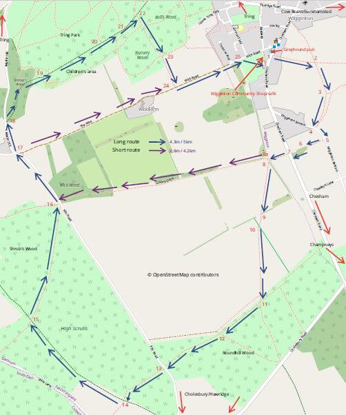
The walk starts at Wigginton Greyhound pub (ask permission first if leaving your car in their car park) or Wigginton Community Shop, where there is free parking. The walk uses part of the Chiltern Way, Ridgeway and Icknield Way. It descends towards Wigginton Bottom, passing an alpaca farm, crosses the Chesham Road before heading towards Roundhill Woods and High Scrubs wood. The route returns via Tring Park, with excellent views over Tring towards Mentmore. The route is mainly on footpaths across fields and through woods, with the option of shortening the walk at several points. The longest route is about 4.6 miles (7.4 km) with an ascent of 336 feet (102 m). Refreshments are available at the Greyhound or Wigginton Community Shop café, depending on the time of day.
You can download a full description and annotated map of the walk here.
START/END: At Wigginton Greyhound pub or Wigginton Community Shop. Marked (1) on the map.
DISTANCE: Approximately 4.3 miles (6.9km)
MAP: Ordnance Survey Explorer 181 Chiltern Hills North
There is evidence of prehistoric settlement around Wigginton, Grim’s Ditch, possibly dating from the Iron Age. In the eleventh century the village was known as Wigentone and controlled by a half-brother of William The Conqueror, Robert, Count of Mortain, builder of Berkhamsted Castle. In 1086, the Domesday Book suggested that Wigginton was acquired by force from two Tring estates. Later the manor was the subject of successive legal challenges in the Court of Chancery until it came into the possession of Sir Richard Anderson, of the manor of Pendley, during the 1650s. Wigginton Common was enclosed in 1854 and was incorporated into Tring Park Estate owned then by the Rothschild Family.
The Walk
Starting with your back to the Greyhound pub car park (1), you will see a footpath sign opposite indicating Public Footpath 8, Crawley’s Lane 1. Carefully cross the road, go through the kissing gate and gently descend towards an open field with views towards Cow Roast. When reaching the open field continue to descend towards another kissing gate and an intersection of paths (2). Take the right-hand path uphill between fields and at the crescent pass to the right of a metal field gate (3) into a more open area with a track joining from the left. Keep right descending towards Wigginton Bottom (4) and at the road, carefully turn left uphill along the road a short distance until a gap in the right-hand hedge with signs for Footpath 21 Chesham Road and the Chiltern Way (5). 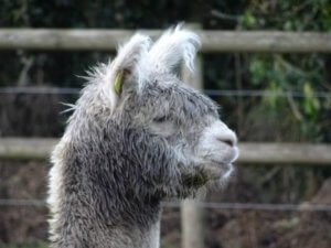 Follow the narrow path as it bends around a house on the left and an alpaca farm on the right (6) until it reaches Chesham Road (7). Cross the road carefully to another kissing gate onto a path signed Chiltern Way and pass into field where there may be cattle, so caution. Shortly there is another kissing gate (8) where the path divides. Those wanting to take the longer route, bear left diagonally across the field underneath overhead electricity cables and right of the pylon. The shorter route (about 3 miles / 5km) goes right, then left behind a gorse hedge (8a), following Grim’s Ditch through Wick Wood to Kiln Road where it re-joins the longer route at point (16).
The longer route heads towards a hedge and another kissing gate (9), then diagonally across the right corner of a field to another kissing gate (10) into a larger field, where a well-marked path heads diagonally right towards Roundhill Wood. Go through the kissing gate (11) into the wood and take the path to the right keeping at the edge of the wood. Caution – there is a four-wheel drive course just inside the wood which passes close to the footpath, so best to keep dogs on a lead. The path heads downhill and at the bottom another path heads off left downhill (12). Ignore this left path and another to the right into the field and carry straight on, slightly left, deeper into the wood towards Kiln Road (13). Carefully cross straight across Kiln Road through a wooden fenced entrance, straight into High Scrubs Wood, following a path, which may be a bit boggy, towards a wide track (14) used by bikes and horses, signed Footpath 12 back to Kiln Road, and Footpath 33. Turn right signed Hastoe, keeping High Scrubs wood on your right until a well-marked footpath (15) is signed to the right, back towards Kiln Road. Follow this footpath as it gently descends, finally meeting another footpath from the left at the exit to Kiln Road (16). Carefully turn left onto Kiln Road and follow it on the right-hand side towards Hastoe Cross-Wick Road (17), where our route joins the Ridgeway National Trail. 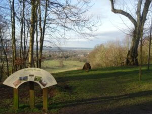 Followers of the shorter route will re-join the main route here and can either turn right onto Wick Road (and save about 0.5 mile or .74km) back towards Wigginton and point 24 on the longer route or follow the longer route through Tring Park. The hardy longer route followers should go along Marlin Road towards the entry to Bishop’s Wood and Tring Park (18), following the Ridgeway and Icknield Way Trails. The wide track through Tring Park gently descends towards point (19), where a wooden carved arch on the right denotes entry to a children’s play area, with carved animals and information about wildlife. Further along the main track is Kings Charles Ride, which forms part of the Ridgeway National Trail. On the left (20) is a seat with an excellent view over Tring towards Mentmore and beyond on a clear day. If the seat is occupied, a little further on (21) is another seat around a tree at the old Rothschild carriage Rond Point or turning circle. In 2013 King Charles Ride was restored by replanting a circle of lime trees at this ‘Rond Point’ and improving the vista over the park and town. A sign gives further information about “Restoring the view” and the park wildlife.
Tring Park formed the estate of the Tring Park Mansion, made famous by the Rothschilds. It was designed around 1682-83 by Sir Christopher Wren for Henry Guy, Secretary of the Treasury to Charles II. Subsequently it was sold to Sir Henry Guy, Lord Mayor of London in 1705 then bought by Sir Drummond Smith in 1786. The latter greatly altered the house and grounds with Charles Bridgeman employed to lay out the grounds, with a summerhouse and other buildings designed by James Gibbs in the early eighteenth-century. In 1872 the Rothschild family bought the manor and partly rebuilt the house but retaining Wren’s plan and conception. The park is Grade II listed by English Heritage, now owned by Dacorum Borough Council and managed by the Woodland Trust.
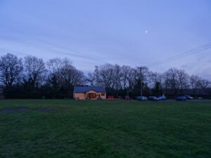 After the viewpoint, carry on a short distance before taking the uphill path on the right (22), which after levelling out, exits the wood (23) on a path alongside a hedge on the left and open field on the right. Follow this path to the metalled Wick Road and turn left (24), watching for occasional farm vehicles. Follow Wick Road into Wigginton and just after Osborne Way on your left, you will see an entrance into Wigginton recreation ground through a hedge (25) on the right. Wigginton Community Shop and Café is straight ahead with the Greyhound pub behind it and the car park to the right.
Useful sources of historical information consulted in compiling this walk included:
Institute of Historical Research – www.history.ac.uk
The Rothschild Archive – https://family.rothschildarchive.org/estates/91-champneys
Woodland Trust – https://tringpark.woodlandtrust.org.uk/things-to-see-and-do/
Historic England – https://historicengland.org.uk/listing/the-list/list-entry/1000218
Walk Directions © George Edwards 2018-19
You can download a full description and annotated map of the walk here.